Donate to Brooks Historical

Showing posts with label virginia. Show all posts

Wednesday, December 15, 2021

Bahamas Shipping Records 1721-1725

In fishing about the Bahamas shipping records 1721-1725 - did you catch the pun, there? - I came across some familiar names of characters in Virginia, North Carolina, or Bahamian pirate history. 

Of course, the Bahamas are just across the Florida Channel from the Carolinas. It's not far away. And, the Lords Proprietors in England owned both properties by 1671, so... anyway, anyone familiar with pirate history should recognize these names.

There's John Vickers, formerly of York River, Virginia, now sailing from Carolina in John Lovick's 22/29-ton sloop Carolina Adventure. Vicker's made a famous deposition concerning pirates Benjamin Hornigold and Henry Jennings at the Bahamas. Lovick was a commissioner, secretary, later vice-admiralty court judge, and naval collector in Carolina; he also was the first Englishman granted Ocracoke Island, where Edward "Blackbeard" Thache was killed in 1718. Small world, right? It actually was in the early 18th century.

John Vickers in 22/29-ton sloop Carolina Adventure

There's also three former pirates who had surrendered to Capt. Vincent Pearse of HMS Phoenix in 1718. 

One, John Cockram, sometimes with his brother Joseph Cockram, mastered the jointly-owned 30-ton sloop of New Providence Richard & John, not surprisingly owned with Richard Thompson, a trader so infamous as a pirate loot dealer or fence that he was represented on Stars! series Black Sails as Richard Guthrie:

Sean Cameron Michael is a South African actor best known for his role as pirate-fence Richard Guthrie

John Cockram, of course, was the real-life pirate doctor aboard Bermudan-transplant of Kingston Henry Jennings' sloop Barsheba. Jennings was the nut crazy enough to raid Spanish La Florida to steal their gold & silver salvaged from 11 Spanish vessels wrecked in the hurricane of July 30, 1715. Jennings also stole a French prize originally taken by Benjamin Hornigold from Bahia Honda, Cuba! Mentioned earlier, John Vicker's deposition talked about this.

John Cockram, master of 30-ton sloop of New Providence Richard & John

But, before Jennings, Cockram sailed with Hornigold in 1714 to steal Spanish goods off Cuba! Newpapers said "said Cockrum fitted out of Providence with 20 Men upon the Coast of Florida" to steal 2,000 pieces of eight from the Spanish. 

The records in CO 27/12, Bahamian Shipping Lists, 1721-1725 also show former pirate Daniel Stillwell as master of his own 5-ton sloop Happy Return, formerly owned by his father in law.

Daniel Stillwell as master of his own 5-ton sloop Happy Return

Hailing from Jamaica, Stillwell married the daughter of Jonathan Darvill before settling on Eleuthera. Borrowing Darvill’s shallop, he and a small crew (including Darvill’s son) captured a Spanish ship off of Cuba which carried over 11,000 pieces of eight around 1714.

Deputy Governor Thomas Walker of Nassau heard about the attack and as Spain and England had recently concluded a peace treaty, had Stillwell and his crew seized. Lacking authority to try Stillwell locally, he had Stillwell sent to Jamaica for trial. Hornigold had been using Darvill’s sloop Happy Return for his own piracy (and some sources indicate Hornigold had been with Stillwell off of Cuba), and had declared that all the Bahamas pirates were under his protection. He intercepted the ship carrying Stillwell and freed him, returning to Nassau to threaten Walker for interfering.

Incidentally, Thomas Walker and his sons are in these shipping records as well. The Walkers owned and operated the 15-ton New Providence-built sloop Industry. Neal Walker mastered the 20-gun Dover of New Providence. Charles Walker mastered the 10-gun Two Brothers of New Providence.

Thomas Walker operated the 15-ton New Providence-built sloop Industry

Stillwell later sailed as a crewmember aboard Hornigold’s ship. When King George offered a general pardon to all pirates who surrendered before September 1718, Stillwell accepted. He later became a ship owner, purchasing several vessels that operated out of the islands, including his father-in-law Jonathan Darvill’s old Happy Return. He sailed to Jamaica with Braziletto wood to trade for 100s of gallons of Rum to fuel Nassau's many taverns. 

Thomas Terrill also appears as master and owner of 12-ton condemned Spanish sloop Endeavor, which probably carries an interesting story of its own, seeing as how the Bahamas had been raided a couple of times by the Spanish. 

Thomas Terrill as master and owner of 12-ton condemned Spanish sloop Endeavor

Two very interesting ship masters hold great meaning for North Carolina's history. One, for 29 June 1721 was for 50-ton sloop Diamond of London, master Matthew "Higgingbotham." Diamond's owner was Samuel Buck, one of several merchants who negotiated with the Lords Proprietors of Carolina and the Bahamas for a 7-year lease of the Bahamas, beginning in 1717. James Gohier was another one who appears as shipowner in these records.

Matthew "Higgingbotham" of 50-ton sloop Diamond of London


An interesting note on the cargo in Diamond states "European goods as p[er] cocquete." Now, 
Merriam-Webster's Definition of coquette shows:

1: a woman who endeavors without sincere affection to gain the attention and admiration of men

2: any of several small, tropical American hummingbirds (genus Lophornis) with the males typically having a colorful or ornate tuft of feathers on the head

The first definition would ironically be appropriate, considering the notorious reputation of Nassau with ladies of the night! Still, I hardly think that the women would be listed as "cargo." The 2nd definition of the exotic birds... well, that, too is doubtful. But, birds can be found there, sure.

No, there's another explanation:

19th cent. "cocquet" or order certificate 

These "European goods" probably were men's powdered wigs, or ladies' fancy corsettes and ordered like on Amazon. Diamond simply delivered the order like an 18th century UPS, "p[er] cocquete."

Another name on these shipping records important to North Carolina is master James Wimble of 5-ton sloop Hardtimes, built in South Carolina and later master of Bermudan-built 5 -ton Bonetta. Wimble had been born in Hastings, Sussex, England and came to the Bahamas when it became free of pirates in 1718. 

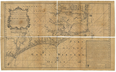
This man was essentially the prime motivator in the development of the town of Wilmington in North Carolina's Lower Cape Fear. Several mariners had been involved in conceiving the town, including this same surveyor and mapmaker Capt. Matthew Higginbotham, who lived for a while in Brunswick Town, across the Cape Fear River from New Town, Newton, New Liverpoole, New Carthage, or as it was finally known in 1740, Wilmington. 


1733 James Wimble Map of Wilmington area


1738 James Wimble Map of North Carolina


Saturday, April 03, 2021

Ancestry of Pirate Henry Jennings


Would it surprise you to know that pirate Henry Jennings is part of a wealthy family of Bermuda and grandnephew of Perient Trott whose other grandchild, Vice-admiralty Judge Nicholas Trott of South Carolina, tried and hanged Stede Bonnet and other pirates for piracy?

The Jennings are also founding fathers of the modern United States, with connections to the grandfather of President George Washington! 

Presenting the surprising genealogy of Henry Jennings:

The original immigrant to Bermuda was Richard Jennings, his will - as listed in Early Wills of Bermuda: 1629 - 1835 by Clara F. E. Hollis Hallett shows:

Capt. Richard Jennings' purchased - mostly from Capt. William Sayles - the maximum amount of land possible for residents on the tiny island of Bermuda: 250 acres.

Richard Jennings may have plotted to take over the government of Bermuda, yet in three years had become a member of the Bermudan Council. He also sold land there to a “Mr. Carter” in England that, in 1656, belonged to Capt. Lawrence Washington, “High Sheriff of Virginia” and great-grandfather of later U.S. president George Washington. The survey of 1663 includes part of his 250 acres of land (the most allowed in tiny Bermuda) in ten properties:

Capt. Jennings' two sons, Richard II and John inherited that property about 1669: Richard II in Smith's Tribe and John in Southampton Tribe.

Bermuda by J. Blaeu. 1647-49

The pirate Henry Jennings descends from John Jennings and Sarah Richards in Southampton Tribe. As the Early Wills of Bermuda shows:

John's will - written in 1684 and probated in 1688 - and compared to information from his father's will, shows that his brother Richard Jennings II had likely married Mary White, the sister of Anthony White. Richard Jennings II captained Charles Gally, cut logwood at the Bay of Campeche, and lost his vessel to pirate Francis Fernando in 1707. The interesting part is that Henry Jennings was later one of ten Jamaican privateers that included this same Francis Fernando!

In 1700, Richard Jennings II made a call at Charles Town, South Carolina and left this notation about his father's will of 1690, including his mother's remarriage to Robert Hall of Bermuda:

Richard Jennings' Will info from South Carolina Probate Records in 1700

John married a Trott, daughter of Perient and Mary Trott and sister of Perient Trott (brother also of Samuel and Nicholas Trott - the later governor of the Bahamas who traded with pirate Henry Avery). John Jennings' only male child was John.

John Jennings, son of John also appears in Early Wills of Bermuda:


 Here, we first see Henry appear, along with brothers Daniel, Richard, and Benjamin and sisters Mary and Sarah. John made this will in 1733 and died in 1740, so was very much alive when his son Henry had gone to the new town of Kingston in Jamaica:

Christian Lilly's Survey of Kingston, Jamaica in 1703

Henry Jennings had purchased two lots in Kingston. He was listed innocuously in shipping records as a mariner involved in “trade.”

British engineer Christian Lilly made a plan (shown above) of the new town of Kingston which included names of subscribers for town lots. “H Jennings” appears twice: one lot on the east side of Orange Street and another on the lower part of King’s. 

As master of Seaflower in 1710, he collected logwood from the Bay of Campeach – like his cousin Richard Jennings III in Charles Gally - and traded slaves on a minor scale to Jamaica. 

Henry was one of many “sugar drovers,” one who had been recorded losing a sloop Diamond, of four guns, in Jamaica in January 1712.  

Colin Woodard found him in “Bathsheba” of Jamaica in Boston’s customs records on July 7, 1715, just a few weeks before the hurricane that year. 

Henry Jennings in Shipping Records of Jamaica

Henry Jennings in Massachusetts Shipping Records of 1715 - located by Colin Woodard and also shows Henry Timberlake - later taken by Edward "Blackbeard" Thache and Benjamin Hornigold in Delight, late 1716.

In only a few months, perhaps influenced by his “Sea Dog” heroes, Henry Jennings became an American pirate legend. Captain John Balchen, of HMS Diamond, wrote to Admiralty Secretary Burchet from Jamaica on the 13th of May, 1716, describing Henry Jennings’ official commission from “Lord Hamilton… for suppressing of piracys.”  Balchen said Jennings sought to capitalize upon the spilled Spanish treasure, not take pirates. Jennings and Wills, guided by their heroes, greed, and holding little regard for the Spanish even in peacetime, stole recovered treasure directly from their salvage base camp on the Florida shore, rather than simply fishing the wrecks in English waters - the more legal route. Trouble was that most of the treasure was on the La Florida or Spanish coast! Jennings would gather together another fleet to go after – not just wrecks – but foreign vessels that he possibly learned about from the Cuban Deputy-governor del Valle’s letter to Hamilton. 

It seems that hunting foreign treasures was about all the English had the desire to do in the West Indies!

By early 1718, Henry returned to his old home place in Bermuda after his short, blatantly illegal run as a pirate. There, he may have contented himself with the family’s smuggling and slave business. Gov. Bennett, who may have been glad to have him back in local business, wrote to the Board, specifically mentioning “Capt. Henry Jennings one of them (who left off that way of liveing [piracy] some months since) has arrived here who with seven others [who] have surrendred themselves.”

Shortly afterward, a Henry Jennings was found sailing in March 1719 from Jamaica to Philadelphia. The next year, the wealthy maritime warrior operated again as a privateer from Bermuda in the next war with Spain, carrying three prize vessels into New York with cargos of “Snuff, Sugar, Oyle Soap, and European Goods.” In 1723, he was captured by another pirate named “Evans” and held prisoner until a quarrel broke out among the pirate crew. Jennings and other “forced men” retook the ship and sailed it back to Bermuda. The Jennings family operated as merchants, slavers, smugglers, and privateers, making their usual runs to Philadelphia, Jamaica, and New York, yet faded from the shipping records by the 1730s. 

Capt. Richard Jennings III of the Somers Islands and a few other captains named Jennings operated sparsely in Bermudan traffic for the following decades. In 1742, as the aging owner of Henry Jennings & Company of Bermuda, this Henry dabbled in the earliest family business, transporting slaves from Africa to the West Indies in the ironically-named Friendship. While likely pirate and mariner Henry Jennings died before 17th of December 1750, a younger “Capt. Henry Jennings” of sloop Ranger, a vessel owned by “Richard Downing Jennings and Henry Jennings of Bermuda” also traded to Philadelphia in 1767.  

The Jennings’ family businesses of smuggling, piracy, and slavery in America – Johnson’s “Commonwealth of Pyrates” – probably continued right up to the American Revolution and beyond. They may even have shared runs with the smuggling Hancocks of Revolutionary-era Boston. 

----------------------------

Most of the genealogy is new research of mine, but the latter detailed part was adopted from the 2020 E-edition of Quest for Blackbeard: The True Story of Edward Thache and His World


Tuesday, December 20, 2011

Wrecked on Hatteras Island: A Long Tradition

The author, Baylus C. Brooks is a graduate maritime historian studying at East Carolina University’s Maritime Studies Program.  He is also a member of the Lost Colony Research Group (LCRG), conducting investigations into North Carolina’s maritime history, including genetic research, genealogy, and archaeology.  Brooks is their official historian. 

Solomon Lumberd was a mariner from Maine who once sailed the Dove to England, claiming to be of the “North Carolina trade” and left his name upon “Lumberd’s Marsh” on one of Hatteras’ earliest deeds near Cape Point; Erasmus Harfleet was a mariner who wrecked on Cape Hatteras in spring 1708; William Reed was a Justice of the Peace and wealthy speculator in North Carolina property, later the "president of North Carolina" and obtained the first deed on Hatteras in Jan 1712 “between the Indian towns”; John Neale was a virtual unknown of some pecuniary significance who lived near or with Hatteras Indians; Patrick and John Mackuen lived nearby to the southwest; Thomas Bilton was a shipwrecked mariner on his way from Lisbon to Virginia… what do all of these people have in common?  They visited and probably worked on Hatteras Island long before the first recorded deeds in 1712-16.  They also left a pile of glorious garbage near Buxton and probably elsewhere for later archaeologists to find.  They probably also married into the Indian population on that island - a population that may or may not have already possessed English DNA.

That’s why the Lost Colony Research Group is looking!  LCRG, headed by genetics specialist Roberta J. Estes, represents a professional group of scholars in history, genetic studies, British and American genealogy, and archaeology whose primary goal is the study of Hatteras Island and its heritage… both native and European.  Hatteras Island Genealogical and Preservation Society works in conjunction with LCRG.  
LCRG recently attained an entry in wikipedia!  This article concerns the history of the island’s English inhabitants and the current working theory of the author. 

Hatteras is a rather small island, only about six miles long at this thicker part between Frisco and Buxton; the official length of the island starts at Oregon Inlet and runs to Hatteras Inlet and is about 18 miles.  At the thickest, it is only three miles wide, but it supported many island families, both native and European, for centuries and packed a sometimes violent maritime history on its Atlantic coast, but a mild and gentle history on its western, or sound side.  The Janus-faced Hatteras thus welcomed and repelled many.  Its waters tore thousands of ships to pieces.

 Washington Times 1906 – Full-page article on the dangers of Cape Hatteras issued after a dangerous hurricane in September 1906.  The inserted map shows numerous shipwrecks associated with Cape Hatteras.  Source: Washington Times (Tacoma), November 1, 1906.
 
On October 30, 1707, a ship sailed from Lisbon, Portugal to arrive upon the “Virginia” sand banks.  It encountered “hard Gales of Wind” and anchored off Cape Hatteras, where the crew “spoke to the Virginians on shore.”  They beat the coast for several months, finally wrecking in the latitude of Bermuda.  From there, nine persons, including Thomas Bilton, made their way in a ship’s boat to Anguilla in the West Indies.  After the wreck, they were thirty-one days at sea and “constrained to drink their own urine.”  This comes from the account of Thomas Bilton in “A Voyage from Lisbon to Virginia,” published in London in 1715.  It is one of the few accounts of contact with the Englishmen living on Hatteras Island prior to recorded settlement.

Another record of a shipwreck only two months or so later, following similar routes from London to Lisbon to America, tells the names of some of these Englishmen upon Hatteras’ shores.  The ship America sailed from London to Lisbon, Portugal, and then ran aground on Cape Hatteras before March 1708.  Erasmus Harfleet survived the wreck and attempted to salvage what he could while on Hatteras Banks, but was stopped by Justice of the Peace William Reed who just happened to be in the vicinity.  A petition was filed by Harfleet on March 11, 1708.  Harfleet “was allowed to work upon the sand banks to save what he could from the wreck.”  But, he encountered William Reed, who “came and threatened him if he took anything belonging to the wreck.”  Since Harfleet said that “Salvage from the wreck was the only wage that the petitioner would receive for his wages from London to the City of Lisbon in Portugal,” he asked for resolution to this argument.  The back of the petition reads, “Patrick MACKANNE, John NACKOUNE, John NEALE, Laruence MARTINSON, witnesses. 11 Mar 1707/8.”  [CCR-192].

It should probably be noted that some years later, Erasmus Harfleet was accused of purposely wrecking a ship in the sound off of Roanoke Island while en route to the area then called “Croatan” (known formerly as “Dasamonquepeuk” and today, as “Mann’s Harbor”) in 1714.  Harfleet was hired by Joseph Parker to pilot the ship, but when the ship ran aground, Harfleet began salvaging the wreck and refused to “get the sloop off” the shoals, who “cursed and said he would never go on board.” Harfleet had already unloaded a boatload of goods onto the mainland before refusing to go back, so he did not seem to mind going aboard the sloop while there were valuables on her.  [CCR-192, 26 Apr 1714]

    Erasmus Harfleet may have been a ner’do’well and justifiably stopped in his “salvage” activities by William Reed that early spring day in 1708.  Still, that encounter with Reed and other “Virginians” on Hatteras Banks tells us something valuable about the activity on that island before its recorded habitation by Englishmen.  Most Hatteras deed records occurred in 1716, although the earliest record we have is a deed for Col. William Reed in 1712 and several others in the following years, so he probably spent a good deal of time there.  At least, he was around to justifiably harass our Mr. Harfleet a few years earlier. 

Dr. David Sutton Phelps (archaeologist from ECU) found a “workshop” locale on Hatteras near the present town of Buxton during his excavations in 1998 that he dated from 1650-1720.  Coins that he found indicated its use by 17th-century Englishmen.  I have postulated before that settlement of Hatteras might have begun as early as the first Virginians arriving south of the Dismal Swamp in the mid-1600s, maybe earlier.  You see, with no roads and numerous creeks inland, travel by water was far easier in those days and Hatteras made a perfect “first stop,” yet, not always a chosen one. 

    Nothing can be certain without written proof, however, but the constant English shipping that began with Jamestown, Virginia since 1607 and that ran past Cape Hatteras on their way from the West Indies and on to London most likely deposited frequent and hapless visitors to Hatteras Island.  Many of them probably remained.  This was the normal trade route, a clockwise voyage from London, to the Canaries, Portugal (long allied with England), across the Atlantic on the trade winds to the West Indies, along the American coast, again picking up the trade winds in the North Atlantic, and then back to England.  This was fed by a desire to deprive the Spanish of their gold and silver, then later, for the sweet white gold of sugar from the Caribbean. No product was ever more valuable than sugar.

    The money is what prompted men like Bilton and Harfleet to brave the obvious dangers of the “Graveyard of the Atlantic” and caused over 2,000 known shipwrecks (actual numbers vary around 5,000).  Ships have found the bottom of these waters since early in the sixteenth century.  Hatteras was not simply an island in North Carolina.  It was a maritime hazard, entrepôt, whaling and porpoise center, and supply station for shipping all along the eastern seaboard.  It must have frequently encountered visitors like Bilton and Harfleet.


Ship Wreckage on Hatteras Island - Photo by Collier Cobb, circa 1900.

Other names mentioned in Harfleet’s petition in 1708 were John and Patrick Mackanne/Nackoune [Mackuen], and John Neale [O’Neale].  These are names also found later in the official deed records of Hatteras Banks.  Both are found in the “Trent Woods” area (today’s Frisco) where we also find the Elks band of Hatteras Indians.

Anna MacKuen was granted 155 acres “between William Rowlason and Patrick Callahan” in 1716 [Pat. book 8, p. 132].  She is probably the wife of John or Patrick MacKuen, seen in the earlier “Harfleet” petition.  Her husband must have died before 1716 when she was officially granted the land – land that the family had most likely lived on for years.  Her neighbors were important men.  Patrick Callahan’s name will appear again.  For now, I’d like to focus on “John Neale.”  He is an important name when it comes to the Hatteras Indians.  It was in 1720, after the Tuscarora War, that John O’Neale was entrusted with the delivery of gunpowder, lead shot, and flints to the Hatteras Indians.  O’Neale was perhaps chosen because his land may have included the “Indian Town” once visited by explorer John Lawson:


John Oneall 1716 patent for 440 acres on Tom King’s Creek - “File No. 1192,  John O’Neal” (October 9, 1716), Land Office: Land Warrants, Plats of Survey, and Related Records, Secretary of State Record Group, State Records, Old Book 8:113-14,  Microfilm S.108.451 (Raleigh, N.C.: State of North Carolina)

John Lawson visited this town circa 1701 and left his record of the Anglicized Hatteras Indians for all to read in his book:  A New Voyage to Carolina; Containing the Exact Description and Natural History of That Country: Together with the Present State Thereof. And A Journal of a Thousand Miles, Travel'd Thro' Several Nations of Indians. Giving a Particular Account of Their Customs, Manners, &c., published in London in 1709.

The mouth of Tom King’s Creek, also known as “Peter’s Creek” (allegedly named for Peter Gordon) in the recent past, begins the boundaries of the later Elks grant of 1759 that was patented for “William Elks and the Rest of the Hatteras Indians.”  O’Neale probably held this property well before 1716 and his relationship with the neighboring Indians seems to have been a good one.  It’s not so easy to call them “Indians” because, as Lawson found, they probably behaved more like Englishmen, shared DNA, dressed, and worshipped like them, too.  Still, living on a remote island far away from prying eyes in the “country,” or mainland as Hatteras islanders once called it, made living openly as something other than “white” far simpler.  [Reference Cecelski’s Waterman’s Song]

John “O’Neill” appears on a Currituck County tax list for 1718, having paid his taxes, unlike Henry Davis and Patrick “Kallahan” who later fought over land boundaries.  This dispute resulted in Henry Davis being killed by Patrick Callahan with a sword.  Callahan then lost his Hatteras property, which just so happened to border both the Mackuen land and John O’Neale.  See map below:


Readjusted 1716 patents in the area of Trent Woods – Base map: 1883 Hatteras map (annotated by Baylus C. Brooks).  A red line represents the mistaken course of Tom King’s Creek and the unforeseen extension of Patrick Callahan’s property in the initial erroneous patents of 1716.  The last frame shows the readjusted property lines as determined from deed and other records.  Mary Davis was too young in 1720 to inherit, but after she came of age and married Thomas Robb, the Jacobite “rebel” who was shipped to Carolina in 1716, they settled in upper Currituck from where they came in 1751 to claim their land.  For about thirty-five years, the Hatteras Indians did not suffer any serious problems with European settlers.  When the Robbs arrived in 1751, they determined that the town was on their land.  The Trent Woods town was readjusted again and granted with 200 acres to “William Elks and the Rest of the Hatteras Indians” in 1759.  Source: “File No. 1190, Henry Davis” (September 12, 1716), “File No. 1196, Patrick Callihan” (October 9, 1716), “File No. 1192,  John O’Neal” (October 9, 1716), Land Office: Land Warrants, Plats of Survey, and Related Records, Secretary of State Record Group, State Records, Old Book 8:113-14,  Microfilm S.108.451 (Raleigh, N.C.: State of North Carolina); United States Coast Survey, “General chart of the coast no. V from Cape Henry to Cape Lookout” (1883), MC.168.1883ub, North Carolina State Archives (Raleigh, N.C.: State of North Carolina).

The “Ungranted” property located in the 1720 frame of this illustration is probably close to the area that Anna MacKuen obtained in her 1716 grant.  Still, it is definitely the known location of Joseph “Maskue/McCun” in 1755-7. 

    John O’Neale, whose eventual fate is not well known, is more than likely the father of Christopher O’Neale (born about 1700).  Christopher O’Neale lived in this same King’s Point area of Hatteras until his death.  He would have grown up around the Indian Town there.  Their families probably all shared a common heritage.  In fact, the O’Neales have owned land (off and on) at King’s Point up until the sale of that property for the development of the high-end subdivision, Brigand’s Bay sometime after the new paved highway developed in 1953.  Part of former O'Neal land also became "Indiantown Shores" subdivison in the 70s. Urias O’Neale sold the bulk of the property that was terra-formed into the lucrative commercial site found there today. 

    The point is that Hatteras Island has been continuously occupied by European descendants since the mid-1600s.  Indeed, many are the ancestors of the same families who walk the island sands now.  They are the ones who left behind the artifacts that Dr. Phelps was digging up along the Buxton or eastern end of the island.  Phelps also found Indian artifacts mixed with European in the same date range.  Englishmen and Indians lived together for decades before John Lawson’s arrival, at least as early as 1670 and possibly earlier.  They could have lived together since 1587 when John White’s “Lost Colony” arrived.  Still, no two heritages more aptly belonged to any single group of people as those of Hatteras Island.  The Indian Town was simply the last holdouts of traditional Indians hoping to hold on to their ways.  This resulted in William Reed’s “between the Indian towns” reference in 1712.  There was little reason to worry, however.  The Englishmen were family already.  Time eventually brought them all together.

    There have been Rollinsons, Wallaces, Whidbees, Quidleys, Basnetts, Fosters, Fulchers, Farrows, Scarboroughs, Midgetts, Davises, Clarks, and many others on Hatteras Island for a long, long time… perhaps since before Nathaniel Batts and George Durant came through the Dismal Swamp in the 1650s and 60s.  Hatteras and the rest of the Outer Banks may have been the only part of what we now know as North Carolina that was inhabited by European people before then.  The mainland suffered from a lack of roads and numerous creeks, no roads, and dangerous unknowns.  The shores along the sounds and rivers is where you would have found the Europeans in the early eighteenth century.  The Indians, of course, were everywhere else... on Hatteras Island at least since 1,000 A.D. 

    When discussing the earliest history of North Carolina, we must begin with the first point of contact… with the Outer Banks, and Hatteras Island, for the sharp sandy snag known as “Cape Hatteras” or its “Diamond Shoals” brought many a drenched mariner to live there long before Batts or Durant dreamed of trading with the Yeopim or the Chowanoc in the Albemarle.  Whereas the Spanish did not remain on the banks, Englishmen did… maybe since 1587.  Certainly, more accounts of shipwrecks upon these shores will turn up, with more tantalizing tidbits of knowledge about the “Virginians” living there.  They continue to live there today.  And artifacts will continue to emerge from its sands to reveal this nascent North Carolina history.  This is Hatteras’ and, indeed, our country’s earliest European heritage.  Still, the native heritage persists there as well… you can ask them yourself.